


Temblor

وصف لـTemblor
A PERSONAL SOLUTION TO A GLOBAL PROBLEM
Half of the world’s population lives near active faults, and so could suffer earthquake damage. Most do not know they are at risk; many of the rest do too little, too late.
Temblor enables everyone in the conterminous United States, and eventually the world, to learn their seismic hazard, to determine what most ensures their safety, and to decide what best reduces their risk.
Temblor works anywhere in the United States, using the best available public data and methods. Our goal is to make earthquake risk ‘real,’ without scaring, soothing, or snowing people. Navigating through Temblor, is quick, fun, and easy. Info buttons explain its calculations, estimates, and data sources.
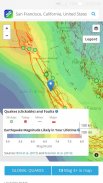
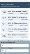
In Temblor’s map you can see the faults and recent quakes around you; use your current location or enter an address. Temblor typically shows magnitude-1.0 or larger quakes in the U.S, and magnitude-4.5 or larger in the rest of the world; the quakes are updated every few minutes. You can click on any quake for more information. Everything is identified in map legends.
The Temblor Seismic Hazard Rank slider lets you know how your location compares to the most and least hazardous sites in the coterminous U.S. By moving the pin around, you can see how your hazard changes, and how it compares to other areas in your commute zone or nearby.
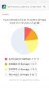
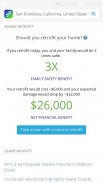
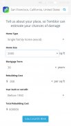
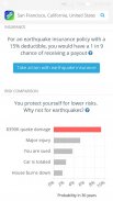
By entering your home’s age and size, Temblor estimates the chances of seismic damage and the cost of repairs in an intuitive, interactive pie chart. Temblor also estimates the cost, and financial and safety benefits of a bolt-and-brace retrofit to your home, so you can assess if this makes sense for you. In addition, Temblor estimates the chances of a payout for a typical earthquake insurance policy for your home at your location.
In an interactive bar chart, Temblor also puts your seismic risk in context. The chart compares your chance of extensive earthquake damage to other perils that most people protect themselves from or insure against, such as a your home burning down or your car being totaled.
In Temblor’s layers menu, you can add liquefaction zones (which can cause a home to sink or tilt when shaken), and landslides (which can cause a home to slide downhill during a quake, or be covered in debris). You can also use a relief map, route map, or satellite image as a base, and zoom in as close as you wish.
Temblor is free and ad-free. Please share Temblor with your friends and family to help our mission to live stronger together.
حل شخصي لمشكلة عالمية
نصف سكان العالم يعيشون بالقرب الصدوع النشطة، وهكذا يمكن أن تعاني أضرار الزلزال. معظمهم لا يعرفون أنهم معرضون للخطر. كثير من بقية تفعل سوى القليل جدا، بعد فوات الأوان.
الزلزال تمكن الجميع في الولايات المتحدة التصوير الجوي، وفي نهاية المطاف في العالم، لمعرفة مخاطرها الزلزالي، لتحديد ما هي الأكثر يضمن سلامتهم، وتقرر ما يقلل أفضل المخاطر.
الزلزال يعمل في أي مكان في الولايات المتحدة، وذلك باستخدام أفضل البيانات والأساليب العامة المتاحة. هدفنا هو جعل مخاطر الزلازل "الحقيقية، من دون تخويف، مهدئا، أو الناس الثلج يتساقط. التنقل من خلال الزلزال، وسريعة، والمرح، وسهلة. أزرار معلومات توضح الحسابات والتقديرات، ومصادر البيانات الخاصة به.
في خريطة الزلزال يمكن أن ترى العيوب والزلازل الأخيرة من حولك. استخدام موقعك الحالي أو إدخال عنوان. يظهر الزلزال عادة بلغت قوته 1.0 أو الزلازل الكبيرة فى الولايات المتحدة، وبلغت قوته 4.5 أو أكبر في بقية العالم؛ يتم تحديث الزلازل كل بضع دقائق. يمكنك النقر على أي زلزال حصول على مزيد من المعلومات. يتم تحديد كل شيء في الأساطير خريطة.
الزلزال المخاطر الزلزالية الرتبة المنزلق يتيح لك معرفة كيف يقارن موقعك لمعظم والأقل الخطرة المواقع في تتزامن الولايات المتحدة عن طريق تحريك دبوس حولها، ويمكنك ان ترى كيف يمكن للتغييرات الخطر الخاص بك، وكيف يقارن إلى مناطق أخرى في منطقة تنقلاتك أو قريب.
عن طريق إدخال سن منزلك والحجم، يقدر الزلزال فرص الضرر الزلزالي وتكاليف التصليح في، الرسم البياني التفاعلي بديهية. ويقدر الزلزال أيضا تكلفة، ومزايا مالية وسلامة التحديثية الترباس وهدفين لمنزلك، حتى تتمكن من تقييم ما إذا كان هذا الأمر يبدو معقولا تماما بالنسبة لك. وبالإضافة إلى ذلك، يقدر الزلزال فرص دفع تعويضات لسياسة التأمين زلزال نموذجية لمنزلك في موقعك.
في شريط الرسم البياني التفاعلي، كما يضع الزلزال مخاطر الزلازل في سياقها. الرسم البياني يقارن فرصتك من أضرار الزلازل واسعة النطاق لمخاطر أخرى أن معظم الناس حماية أنفسهم من أو تأمين ضد مثل منزلك يحترق أو سيارتك يجري بلغ.
في قائمة الطبقات الزلزال، يمكنك إضافة مناطق تسييل (الذي يمكن أن يسبب موطن لتغرق أو إمالة عندما اهتزت)، والانهيارات الأرضية (التي يمكن أن تتسبب في المنزل لتنزلق نزولا خلال الزلزال، أو تكون مشمولة في الحطام). يمكنك أيضا استخدام خريطة الإغاثة، وخريطة الطريق، أو صورة الأقمار الصناعية كقاعدة، والتكبير في أقرب وقت كما يحلو لك.
الزلزال مجاني وخالية من الاعلانات. يرجى حصة الزلزال مع أصدقائك وعائلتك للمساعدة في مهمتنا أن يعيش أقوى معا.


